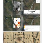
Just in time for the start of field excavations in Patterson Park next week, Dr. Tim Horsley has shared some initial findings from his remote sensing survey of Hampstead Hill last month. Tim created the images and maps pictured using data from soil resistivity and ground-penetrating radar surveys that revealed the location of a structure in the park and (as Tim writes) what “looks suspiciously like a cellar or basement to me.”
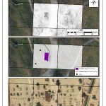
The map of the Civil War encampment at Patterson Park excerpted in Tim’s survey above suggests that the structure located at the site was used as the “Keeper’s House” in the 1860s (a function later replaced in 1868 by the Superintendent’s House used by the Friends of Patterson Park as an office today).
However, our project team suspects the structure may be much older and could have originally been built by Jacob Loudslanger as the tavern and butcher’s shop that first gave the adjoining neighborhood the name of Butcher’s Hill. Historian Scott Sheads has documented how General Samuel Smith occupied Loudslanger’s tavern as his field headquarters during the Battle of Baltimore sending orders from Hampstead Hill to the troops at the Battle of North Point and to the forces stationed at Fort McHenry—a story that makes this possible discovery a very exciting find.
Has our search for the War of 1812 already turned up the original butcher on Butcher’s Hill? Only additional research and archeology this spring can help answer that question. Learn more about We Dig Hampstead Hill and please join us next week for our volunteer workshop.
One comment